top of page
Remote Sensing
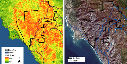
Burn Severity of Big Basin, Santa Cruz County, CA using Landsat 8
Fire studies have become increasingly important due to large scale wildfires occurring more frequently. We used Landsat 8 imagery to classify burned and non-burned areas and then compared these results with observations made in the field.
Remote sensing Post-Fire Succession of Chaparral Cover in Fort Ord, Monterey County, CA using MODIS-EVI
In the maritime chaparral of the Fort Ord National Monument (FONM) a study was conducted to validate the accuracy of MODIS satellite’s Enhanced Vegetation Index (EVI) to measure the density and greenness of chaparral in the post-fire succession.

bottom of page